


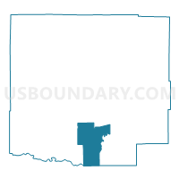
Crowley 6, Crowley County, Colorado
About
Outline

Summary
| Unique Area Identifier | 547118 |
| Name | Crowley 6 |
| County | Crowley County |
| State | Colorado |
| Area (square miles) | 31.91 |
| Land Area (square miles) | 31.81 |
| Water Area (square miles) | 0.10 |
| % of Land Area | 99.68 |
| % of Water Area | 0.32 |
| Latitude of the Internal Point | 38.17607330 |
| Longtitude of the Internal Point | -103.77568730 |
Maps


Graphs
Select a template below for downloading or customizing gragh for Crowley 6, Crowley County, Colorado


Neighbors
Neighoring Voting District (by Name) Neighboring Voting District on the Map
- Crowley 2, Crowley County, CO
- Crowley 3, Crowley County, CO
- Crowley 4, Crowley County, CO
- Crowley 5, Crowley County, CO
- Otero 13, Otero County, CO
- Otero 14, Otero County, CO
Top 10 Neighboring County Subdivision (by Population) Neighboring County Subdivision on the Map
- Rocky Ford CCD, Otero County, CO (5,426)
- Ordway CCD, Crowley County, CO (5,398)
- Sugar City CCD, Crowley County, CO (425)
Top 10 Neighboring Place (by Population) Neighboring Place on the Map
Top 10 Neighboring Unified School District (by Population) Neighboring Unified School District on the Map
- Crowley County School District RE-1-J, CO (5,643)
- Rocky Ford School District R-2, CO (5,500)
- Manzanola School District 3J, CO (919)
Top 10 Neighboring State Legislative District Lower Chamber (by Population) Neighboring State Legislative District Lower Chamber on the Map
Top 10 Neighboring State Legislative District Upper Chamber (by Population) Neighboring State Legislative District Upper Chamber on the Map
Top 10 Neighboring 111th Congressional District (by Population) Neighboring 111th Congressional District on the Map
Top 10 Neighboring Census Tract (by Population) Neighboring Census Tract on the Map
- Census Tract 9696, Crowley County, CO (5,823)
- Census Tract 9681, Otero County, CO (2,718)
- Census Tract 9682, Otero County, CO (2,708)